The bridge of the Bourbon Liberty 101: episode 1
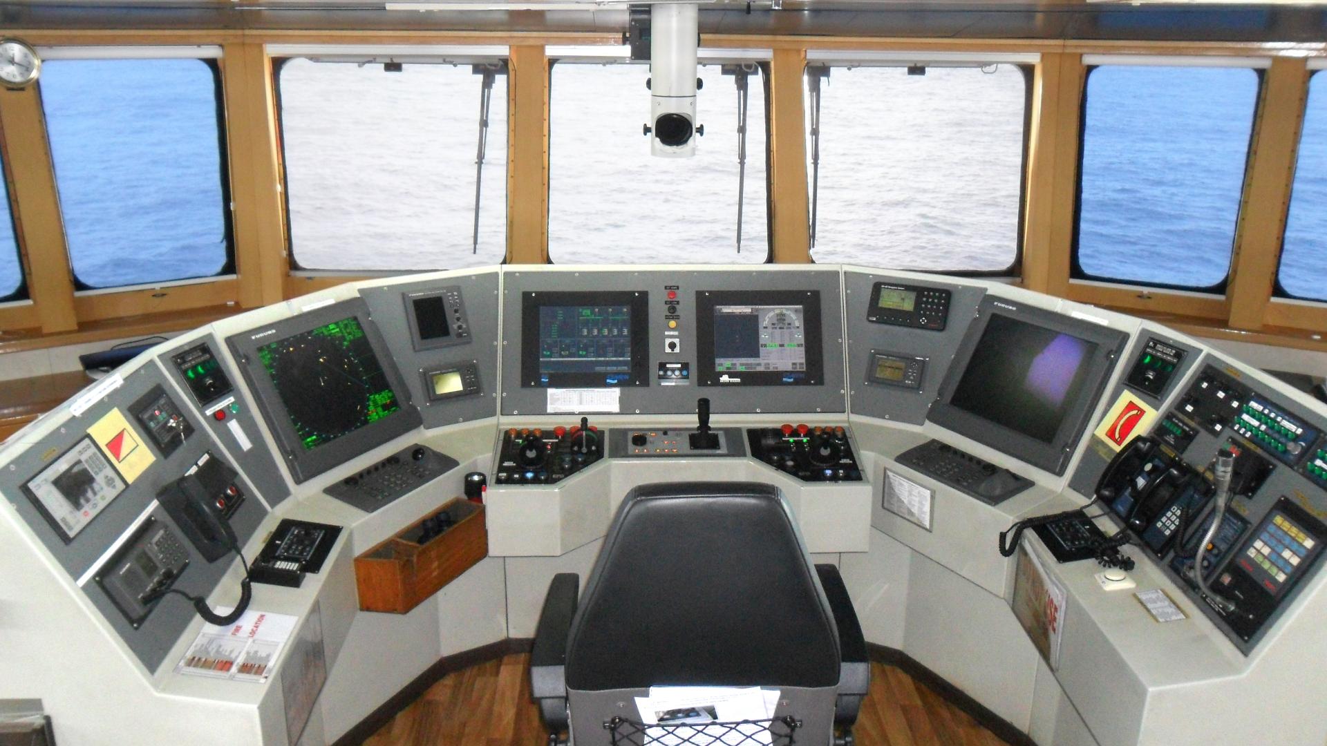
The bridge of a vessel is its command post. Largely glazed, it generally offers a 360° view of the outside environment. There are two pilot stations, the first one for navigation, facing the bow, and a second one for operations management, facing the afterdeck. A guided tour aboard the Bourbon Liberty 101, a diesel-electric DP2 PSV (Platform Supply Vessel), dedicated to supplying offshore facilities, with its captain Didier Calvo, who describes the navigation station for us.
These days, the design of the navigation station enables the watch officer to have everything at his fingertips. Each of these elements contributes to the operation of the vessel, the safety of property and people, and to decision-making.
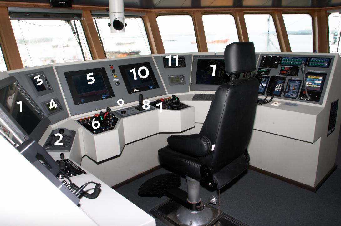
After clicking on the photo, see the description of each equipment below.
1 & 2 - ARPA Radar (Automatic Radar Plotting Aid) and its associated keyboard (Port and Starboard)
The ARPA radar is a navigational radar equipped with an echo monitoring aid to help the seafarer in choosing a maneuver to avoid a collision.
Upon the appearance of an echo, after 3 minutes of acquisition, the system calculates 4 important elements that will help the seafarer in his decision to make a maneuver:
- CPA (Closest Point of Approach) the nearest point that the echo could reach with regard to our vessel
- TCPA (Time to Closest Point of approach), the time to reach the CPA
- the surface route
- the echo's surface speed (see explanation 4)
3 - Echo sounder
While a seafarer really wants to know the dangers that lie above the surface, he also wants to know the underwater hazards, to prevent grounding.
The lead line has been replaced by an ultrasonic range finder. This device sends out electrical pulses. Depending on the intensity and speed at which the pulse returns to the probe, the range finder identifies the depth as well as the nature of the bottom. Warm colors (red) indicate that the bottom is hard (rock), while cool colors (blue) indicate that the bottom is soft (mud).
4 - Log
Another navigational instrument essential to the seafarer, the log estimates the speed of the vessel's movement on the water.
This speed is called "surface speed" because it is a rate calculated with regard to the body of water where the vessel is moving, a body of water which is also moved by the currents.
5 - VMS (Vessel Monitoring System)
This touch screen, available from the bridge, the chief engineer's cabin, and machine control station, is used in particular to control critical engine (pressures, temperatures, rpm, generator status, power output) and propeller (rpm, bearing temperatures, etc.) parameters.
6 & 7 - Controls of the vessel (propulsion - steering)
One characteristic of this type of vessel: gone is the ship wheel connected to the rudder... there's no rudder! The ship has:
- 3 aft propellers mounted on Pods, the central Pod of which remains fixed. The Pod is a system that enables the propeller, in addition to spinning, to rotate 360 degrees. It's like having an outboard motor with a tiller. If you want to turn right, you have to direct the left pod to steer the aft left and therefore turn right.
- 2 bow thrusters. This propulsion system, which tends to be developing in the offshore industry, enables the ship to maneuver in tight spaces.
8 & 9 - Dynamic Positioning control station
The joystick has a dual function:
- in autopilot mode, it lets you raise or lower the vessel's speed
- in Dynamic Positioning (DP) mode, it lets you move the vessel by synchronizing the vessel's entire propulsion system, like a game console. Next to it is the heading dial (Rotary Knob) for switching to DP mode.
10 - Dynamic Positioning Monitor
The second touch screen is used for both autopilot but also to control the dynamic positioning. In autopilot mode, the bridge returns a heading and the system maintains this heading by managing the rotation of the Pods.
In dynamic positioning mode, the bridge controls its position to an accuracy of 1 meter!
11 - GPS
Everyone knows GPS in a car. The principle here is the same, with different functions of course. In addition to giving our position down to the nearest meter and the bottom speed observed, the captain inserts his chosen route. The GPS provides information like the distance to be traveled, the discrepancy with regard to the pre-established route, the time remaining to reach the next turning point, and the end point.
The new GPS include calculations of tides. Simply enter the port and sine characteristics of the tide at this place to obtain the tide curve, the water level, for any date and time you want.
Please find very soon the end of the Bourbon Liberty 101 bridge description in the episode 2!
